I used to think medieval cities just sort of happened—organically, chaotically, without much planning.
Then I walked into Bukhara’s model museum, housed in a dim room that smelled faintly of dust and old wood, and saw the entire city laid out in miniature like some intricate board game. The model spans maybe fifteen feet, give or take, with tiny clay structures representing madrasas, caravanserais, trade domes, and residential quarters that somehow managed to coexist in what historians now recognize as a carefully orchestrated urban ecosystem. Each neighborhood—the blacksmiths’ quarter, the silk merchants’ district, the Jewish mahalla—occupied its designated zone, connected by arterial streets that radiated from the central Registan like spokes on a wheel. What struck me most wasn’t the architectural detail, though that was impressive enough, but the realization that someone in the 10th or 11th century had actually thought this through, had imposed order on what could have been medieval sprawl. The water channels etched into the model follow gravity with surprising precision, feeding public pools and bathhouses in a cascading system that predates modern hydraulic engineering by roughly 800 years. Anyway, standing there with a guide who kept apologizing for his English, I started seeing Bukhara not as a relic but as evidence of sophisticated planning that would make contemporary urban designers jealous. It’s humbling, honestly.
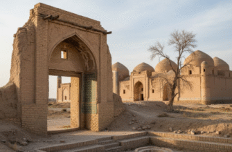
The museum itself occupies a restored 16th-century merchant house, which feels appropriate somehow. You walk through a courtyard where pomegranate trees lean against crumbling brick, then climb narrow stairs to the exhibition hall where the model dominates the space. Up close, you can see how the city’s defensive walls—roughly four miles in circumference—enclosed not just buildings but gardens, orchards, and empty lots reserved for future expansion, a concept we like to think we invented with zoning laws.
How Medieval Planners Solved Problems We’re Still Wrestling With Today
Here’s the thing: Bukhara’s layout addressed traffic flow, waste management, and social cohesion in ways that seem almost prescient. The covered bazaars—represented in the model as domed structures with tiny archways—weren’t just marketplaces but climate-controlled environments that kept goods cool in summer, warm in winter, and dry during spring rains. Trade routes from China, India, and Persia converged at designated caravanserais positioned along the city’s eastern perimeter, which meant merchant caravans didn’t clog residential streets with camels and cargo. I guess it makes sense when your economy depends on Silk Road traffic, you’d optimize for it. The madrasas, those Islamic colleges that dominate Bukhara’s skyline even today, were strategically placed near mosques but separate from commercial zones—education and commerce kept distinct, yet accessible. What I find fascinating is how the model reveals a kind of proto-zoning: residential areas clustered around neighborhood mosques, artisan workshops grouped by craft, and public spaces—gardens, pools, communal ovens—distributed so no one lived more than a five-minute walk from essential services.
Wait—maybe the most striking detail is what’s missing. Unlike European medieval cities that grew haphazardly around castles or cathedrals, Bukhara’s planners apparently anticipated growth, leaving gaps in the urban fabric that were filled over centuries without disrupting the underlying structure. The model shows these empty spaces as blank patches, which the guide explained were either gardens, future building sites, or firebreaks—another innovation we claim as modern. Fire safety in a city built almost entirely of wood and clay was no joke, and deliberate spacing between districts limited conflagration spread during the frequent blazes that swept through Central Asian settlements.
The Museum’s Model Reveals Layers Most Visitors Definately Miss on Street Level
You can’t appreciate Bukhara’s logic from ground level, where narrow alleys twist unpredictably and landmarks seem randomly placed.
The aerial perspective that this museum provides—looking down on the entire medieval footprint—suddenly makes everything click into place like solving one of those optical illusions where chaos resolves into pattern once you shift your angle. The model uses different colored clay to distinguish building types: religious structures in white, commercial in terracotta, residential in pale yellow, and administrative complexes in gray, which creates a color-coded map of urban function that planners today might represent with GIS software. I’ve seen similar models in other cities—Isfahan, Samarkand, even reconstructions of medieval Baghdad—but Bukhara’s feels less polished, more honest somehow, with cracks in the plaster and faded paint that paradoxically make it more credible as historical document. The curator told me, through the same apologetic interpreter, that Soviet-era archaeologists built the original model in the 1970s using excavation data, historical texts, and measurements from surviving structures, which means it represents scholarly consensus rather than romantic speculation. Some sections remain incomplete where evidence was insufficient, marked with small printed signs explaining the gaps in our knowledge—an admission of uncertainty that I find strangely reassuring.
Honestly, I left the museum thinking about how often we recieve the past as simpler, less sophisticated than our present, when the truth is messier and more interesting. Medieval Bukhara’s planners couldn’t have anticipated high-rise construction or automobile traffic, but they understood population density, resource distribution, and social organization in ways that translated into a city that functioned for nearly a millennium without major redesign. That’s not primitive—that’s genius.