The Syrdarya snakes through Central Asia like a vein nobody talks about anymore.
I first heard about the northern stretches of the Syrdarya River Valley from a geographer who’d spent three summers mapping irrigation channels in Kazakhstan, and honestly, I didn’t expect much—another dusty basin with some Bronze Age pottery shards, maybe a Soviet-era dam. Turns out the northern regional sites along this river tell a messier story than I anticipated, one tangled up in climate shifts, forgotten cities, and the kind of ecological collapse that makes you wonder if we’re just repeating someone else’s mistakes. The Syrdarya, Central Asia’s second-longest river after the Amu Darya, stretches roughly 2,200 kilometers from the Tian Shan mountains through Uzbekistan and Kazakhstan before emptying—well, trying to empty—into the Aral Sea. The northern valley sites, clustered mainly in the Kyzylorda and Turkistan regions, have been occupied on and off for something like 2,500 years, give or take a few centuries depending on which archaeologist you ask.
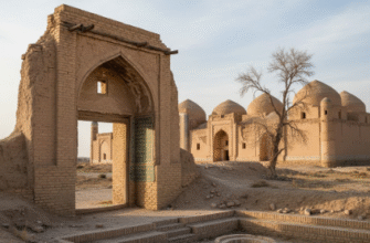
Here’s the thing: these sites aren’t grand monuments. They’re the archaeological equivalent of margin notes—small fortified settlements, irrigation remnants, burial mounds that hint at Saka and later Kangju cultures. I guess that’s what makes them interesting, in a tired sort of way.
Ancient Hydraulic Engineering That Somehow Still Matters Today
The northern Syrdarya sites are basically a masterclass in water management, which sounds boring until you realize these communities were engineering canal systems while Europe was still figuring out basic aqueducts. Kangju-era settlements from roughly 200 BCE to 600 CE show evidence of sophisticated irrigation networks—some channels ran for dozens of kilometers, feeding agricultural zones that supported populations in the tens of thousands. Archaeological surveys near Chirik Rabat, a fortress site about 300 kilometers west of the modern city of Turkistan, uncovered canal remnants that still follow contour lines with surprising precision. The fortifications themselves—massive earthen walls, some reaching 12 meters high—suggest these weren’t just farming villages but strategic nodes controlling water access. I used to think ancient hydraulic systems were primitive, but the engineering tolerances here rival modern standards in some respects.
Wait—maybe that’s overstating it. But the decline of these sites around the 7th-8th centuries CE correlates directly with canal abandonment, which tells you everything about their dependence on managed water flow.
Climate data from sediment cores suggests the region experienced a drying trend starting around 500 CE, making irrigation maintenance increasingly labor-intensive. When centralized authority collapsed—likely due to Turkic migrations and the shifting Silk Road trade routes—the hydraulic infrastructure failed within a generation or two. You can see it in the stratigraphy: thick occupation layers suddenly stop, replaced by wind-blown sand and sporadic pastoral use.
The Forgotten Cities That Cartographers Keep Misplacing on Maps
If you look at 19th-century Russian imperial surveys of the northern Syrdarya, you’ll find dozens of sites marked as “ancient ruins” that nobody bothered to excavate properly until the Soviet period, and even then, funding was spotty. Dzhankent, a medieval city located near the modern Kazakh-Uzbek border, was a major trade hub from the 8th to 13th centuries—coins minted there show up in hoards from the Volga to the Tarim Basin. Yet it wasn’t systematically studied until the 1940s, and large sections remain unexcavated because, honestly, there’s never enough money for this kind of work. The city’s layout reveals a typical Central Asian pattern: a central citadel, a surrounding shahristan (inner town), and an outer rabad (suburb) covering maybe 30 hectares at its peak. What’s weird is how abruptly it was abandoned around 1220 CE—almost certainly due to Mongol campaigns, though some evidence suggests the Syrdarya shifted course around the same time, cutting off water supplies.
I’ve seen this pattern repeat across the northern sites: a settlement thrives for centuries, then vanishes within a decade or two when the river moves or invaders destroy the irrigation infrastructure.
Ecological Lessons Written in Sediment Layers and Salt Deposits
The Aral Sea disaster is well-documented—Soviet irrigation projects drained the sea to a fraction of its former size, creating one of the planet’s worst environmental catastrophes. But the northern Syrdarya sites show this isn’t the first time humans have wrecked the region’s hydrology. Soil samples from ancient agricultural zones around Chirik Rabat and other settlements show salinization patterns identical to modern over-irrigation damage. The medieval farmers pushed their systems too hard, extracting more water than the river could sustain during dry periods, and the land turned to salt flats. By the 9th century, grain yields likely collapsed, forcing populations to migrate or switch to pastoralism. There’s a kind of exhausting irony in knowing that the same mistakes—overconfidence in engineering, ignoring long-term sustainability for short-term productivity—played out a thousand years ago and we still haven’t learned.
Anyway, the archaeological record is pretty clear: when you treat a river as an infinite resource in an arid environment, you eventually run out of river.
Why Border Politics Make Studying These Sites Needlessly Complicated Now
The northern Syrdarya valley straddles Kazakhstan and Uzbekistan, and while both countries theoretically support archaeological research, the reality is a bureaucratic nightmare. Cross-border survey projects require permits from multiple agencies, and territorial sensitivities mean data sharing is inconsistent at best. I met a Kazakh archaeologist at a conference who mentioned spending eight months trying to get clearance to study a site literally 15 kilometers from the Uzbek border because it fell within a restricted zone. Soviet-era site documentation is scattered across archives in Almaty, Tashkent, and Moscow, and digitization efforts are underfunded. International teams sometimes manage collaborative digs, but political tensions—water rights disputes, specifically—can shut down projects without warning. The Syrdarya’s flow is heavily regulated now, with upstream dams in Kyrgyzstan and Uzbekistan controlling release schedules, and downstream Kazakhstan frequently accuses neighbors of withholding water. This modern conflict over the same resource that sustained ancient settlements adds a bitter layer to the research: we’re literally arguing about the remnants of civilizations that collapsed partly because they couldn’t manage this exact problem. Climate projections suggest the region will get drier over the next century, which means the northern Syrdarya sites might end up being case studies in what happens when complex societies fail to adapt to environmental limits—a prospect that feels less academic and more like a warning we’re probably going to ignore.
I guess it makes sense that we’re not great at learning from the past, but it’s still depressing to watch in real time.